Map of Alicante Area
Sometimes, the names in Spain can get confusing. The Spanish can call with the same name to a city, an area or province, and to an airport and yet you will find many other cities with completely different names in the area. Let’s going to check how the map of Alicante area looks like.
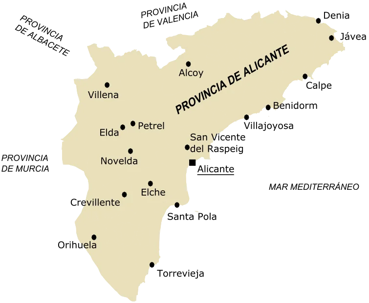
As you can see on the map, there are many cities in Aliante’s province or area. We probably know already where is Alicante, Spain but we might miss where are a few of the other towns. Some of them are well known as a tourist destination. The total population in the area is 1838819 people in 2018. That makes Alicante area the 5th province most populated in Spain.
A very well known city in Alicante province is Benidorm. It is just half an hour drive from Alicante city and had 40087 hotel beds in 2016. That made Benidorm the 3rd Spanish city with more overnight stays in 2016. Let’s going to take a look at the distances and ways to travel from Alicante to a few of the biggest cities in the area or province.
Distance Between the Biggest Cities of Alicante Area
| City | Distance from Alicante | Train connection? |
| Benidorm | 28.65mi (46.1km) | Yes, TRAM |
| Jávea | 53.44mi (86km) | No |
| Calpe | 39.71mi (63.9km) | Yes, TRAM |
| Torrevieja | 31.19mi (50.2km) | No |
| Santa Pola | 12.05mi (19.4km) | No |
| Orihuela | 36.91mi (59.4km) | Yes, Renfe |
| Villena | 35.85mi (57.7km) | Yes, Renfe |
| Alcoy | 37.72mi (60.7km) | No |
| Villajoyosa | 20.19mi (32.5km) | Yes, TRAM |
| Dénia | 56.86mi (91.5km) | Yes, TRAM |
| Crevillente | 24.66mi (39.7km) | Yes, Renfe |
| Elda | 23.30mi (37.5km) | Yes, Renfe |
I hope this text helps you to have a better idea of how the map of Alicante area looks like and how big it is. If you have any other concern or doubt about it or you want to share your experience on any of the towns in Alicante province, please, feel free to leave a comment!